Recommended routes and roadside stops from all directions on the way to and through Wyoming’s Wind River Country.
From the Southwest
To reach Wyoming’s Wind River Country from the southwest, you will likely start on Interstate 80 going east. You will need to look for the Highway 372 exit a few miles east of Little America. Turning north on Highway 372 will lead you along the west side of the Green River. The highway is on the tableland above the river, so you won’t see much of the river itself. The Oregon, California, and Mormon Trails cross the highway. About 20 miles north of I-80, look to the right for a concrete post four feet tall marking the Oregon Trail where the ruts are visible. There are no fences here and you can stop the car and walk along the trail if you wish. Please do not drive on the trail since it is a national treasure we want to preserve.
Twenty-seven miles after turning off I-80, you will turn right onto Highway 28 toward Farson. This is open range country, so you might have to slow down and wait for an antelope, deer, cow, or cowboy. Look for the concrete posts again on either side of the road because the Oregon Trail crosses this road a number of times. Look for the Simpson Hollow marker located about 10 miles after turning onto Highway 28. If you have time, stop and read it. It mentions the conflict between the U.S. government and the Mormon people.
Farson is a crossroad with a few stores. If you didn’t stop here for one of the famous ice cream cones at the Mercantile, you will be missing a legend.
Continue east on Highway 28 toward the Continental Divide. Off in the distance to the left you will see the legendary snowcapped Wind River Mountains. These mountains were a formidable barricade to the western-bound pioneers. Were it not for the South Pass of the Continental Divide, our country would not be as we know it today.
About 26 miles east of Farson, three county lines come together (Fremont/Wind River Country, Sweetwater, and Sublette). On the left is a fenced-in area about the size of a football field. Oregon Trail markers are located inside. The trail is easy to see here and well worth the stop. This area has become known as the “False Parting of the Ways.” It is not the California turn-off of the Oregon Trail as originally speculated.
Continuing north, you will cross the Continental Divide. If it were not for a roadside sign to designate the divide, you would not know you were crossing the spine of the American West the pass is so gentle.
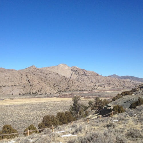
Approximately 40 miles from Farson, start looking for signs pointing the way to the gold mining towns of South Pass City and Atlantic City. These ghost towns are located just a few miles off the main highway to the right. The two ghost towns are connected by wide, well maintained gravel roads. I urge you to take the time to visit these special towns in the summer and fall. South Pass City is a national treasure maintained by the State of Wyoming. At one time 5,000 gold mining, adventurous, fortune seekers lived here trying their best to make a go of it. In the end they all failed. What remains is an unequaled and unique window into Western American history.
Heading north once again on Highway 28, you will begin descending into the heart of Wind River Country. About five miles from the Atlantic City turn-off, you will see an abandoned open pit iron mine on the left. The ore processed into taconite pellets was hauled 275 miles by rail to Orem, Utah, to be made into steel. This area is presently undergoing reclamation.
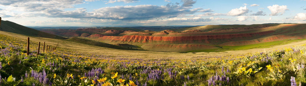
A few miles further you will pass Red Canyon on your left. This red soil dates back 200 million years to when dinosaurs ruled the earth. There are several parking areas here which offer grand photo opportunities. The canyon is also an elk wintering area.
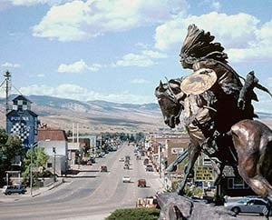
From here, you travel on to Lander. The Lander Visitor Center and Chamber of Commerce is located on the right about a block past McDonald’s and is an excellent resource.
Have you heard of the Sinks? Be sure to ask about this one. You won’t believe it even when you see the rushing river slam into a rock wall and disappear. Sinks Canyon State Park, located just a few miles from town, is maintained by the State of Wyoming with no charge to visitors.
From Lander, I recommend you drive over to Riverton. Be sure to visit the Wind River Heritage Center, the 1838 Mountain Man Rendezvous grounds, and the shops on Main Street. Here are some more ideas.
If you are heading to Yellowstone and/or Jackson from Riverton, you will go west on Highway 26 to the beautiful and rustic mountain town of Dubois. On the way, be sure to watch for the recently introduced Wind River Reservation bison herd just past the tiny town of Morton on the left. About halfway to Dubois, you will pass Crowheart Butte on your right. There is a large wooden historic marker on the left side of the road with ample parking explaining one story of this formation.
 Dubois has great restaurants, comfortable lodging, and a number of art galleries. Learn more about all you can do here, from watching bighorn sheep in rut to mountain biking and learning to square dance at duboiswyoming.org.
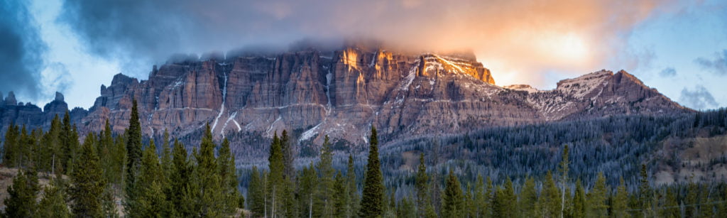
From Dubois you will start the gradual climb over Togwotee Pass and the Continental Divide on Highway 26 where scenery abounds. The jagged rock cliffs to the right of the highway are called the Pinnacles and are part of the Brecia. Keep your eyes peeled for a sign marking Wind River Lake on the right side of the road just before you cross the Continental Divide. One of the many campgrounds located on the Shoshone National Forest, this easily accessible lake affords great fishing, picnic tables and restrooms. Besides, the setting of the lake under Sublette Peak is breathtaking.
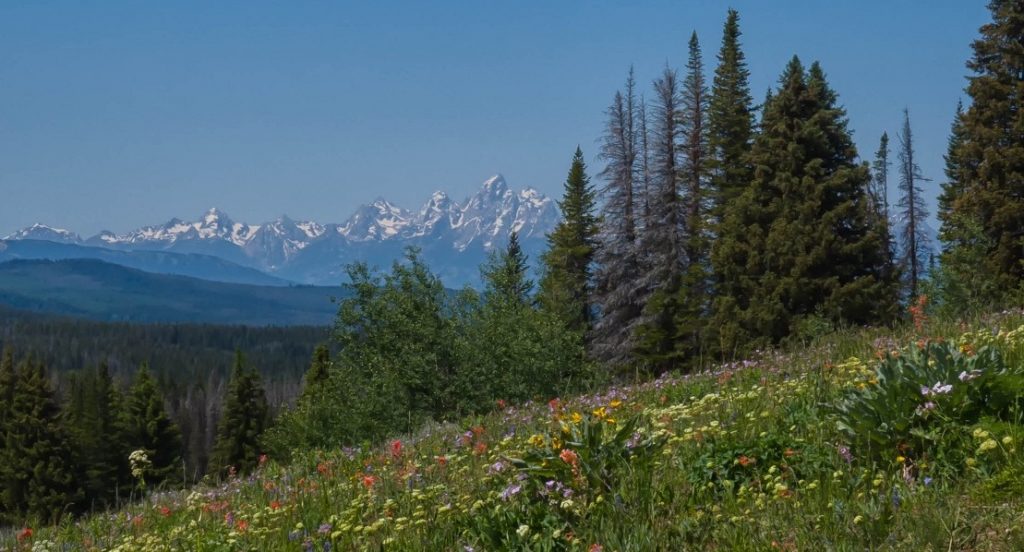
As you begin the descent into Yellowstone and Grand Teton National Parks, just before you leave Wind River Country, you will be treated to a spectacular view of the mighty Teton Mountain Range and the Grand Teton.
From the Northeast
If your route to Wind River Country is from the northeast, you will enter Wyoming from South Dakota on Interstate 90. Once inside the Cowboy State, you will eventually reach the town of Buffalo. Looming high above this historic little community are the majestic Big Horn Mountains. Highway 16 west from Buffalo is one of the most scenic routes along these incredible mountains and the best way to gain access to the many recreational options in them. The highway into the Big Horn Mountain Range climbs gradually to the summit of a 9,666-foot Powder River Pass. This is a favorite route to Wind River Country.
The descent down the west side of the mountains into the Big Horn Basin is every bit as colorful as the climb up the east side. Stay on Highway 16 until you reach Worland, a busy agricultural community that always has a welcome mat out for visitors. At the intersection of Highway 16 and 20, go straight ahead to Highway 20 which turns south outside of town.
The next major community you will pass through is Wind River Country’s nearest neighbor in this direction, Thermopolis. The Hot Springs State Park is located on your left as you come into town. There are a number of choices for soaking and recreational pools, some of which are free. These water pools are fed by the world’s largest hot water springs. The park is colorful and educational.
The drive from Thermopolis to Riverton is spectacular. Just outside of Thermopolis, you will notice a steep uplift that reaches all the way up to the Owl Creek Mountains. At first sight, this wall of mountains appears to be a formidable barrier. However, as you approach the mountains, instead of climbing up and over them, the road will dip as you head into the legendary Wind River Canyon on a Scenic Byway. Your entry into the canyon will also mark the gateway to Wind River Country and the boundary of the 2.2 million-acre Wind River Indian Reservation.
At this point I need to clarify a question that may arise as you drive. There are not two different rivers in this canyon. There is only one, and it has two names. This is because the river was named by two different groups of mountain men in the early 1800s. The first half of the river from its source to the mouth of this canyon was called the Wind River. The river’s name becomes Big Horn from the mouth of the canyon to its confluence with the Yellowstone River in Montana.
The Wind River Canyon is about 15 miles long, and in areas the rock walls are composed of some of the oldest rock on Earth. Roadside signs will tell you the names of the various formations and their approximate ages.
There are three tunnels at the south end of the canyon. After you pass through the third tunnel, you will see the lower campground of the Boysen State Park on your right. The upper campground is a few miles further down the road, but this is just the beginning. Boysen State Park is Wyoming’s largest state park and includes many campgrounds and recreation areas around the reservoir and on the river. You can’t miss the dam and the lake on your right as you drive out of the canyon. Visitor information is available at park headquarters a few miles beyond the dam on your left. Fishing and boating are always great on the 20-mile long Boysen Reservoir. If you don’t pack a pole or boat, you can always enjoy a swim, picnic, or hike in the park.
After driving the length of Boysen Reservoir, you will reach the small town of Shoshoni, one of the nearest places to the reservoir to pick up supplies. At the main intersection in town, you will turn right onto Highway 26 for the final, 20-mile stretch to Riverton.
You will enter Riverton on Federal Boulevard. Watch for the large green overhead signs and turn right on Main Street. Explore a bit and then load back into the car to visit the Riverton Museum, Wind River Heritage Center, and the 1838 Mountain Man Rendezvous site. Here are some more great ideas for a day in Riverton.
It is only 24 miles from Riverton to Lander on Highway 789. As you drive these miles and enter this picturesque community, soak up the views of the Wind River Mountains ahead. Upon reaching Lander, turn right just after McDonald’s. Stop in at the Visitors Center then head out to explore town and the outdoor recreation opportunities that surround it.
Don’t miss Sinks Canyon State Park. You won’t believe it even when you see the rushing river slam into a rock wall and just disappear. This geographical wonder is in a state park that is free to visitors.
For more incredible views and some fascinating history, head southeast out of Lander to see Red Canyon and visit the old gold mining ghost towns of Atlantic City and South Pass City State Historic Site.
After you’ve explored Lander and South Pass, take Hwy 287 north to Fort Washakie. Though you’ve only been back on the road for 16 miles, you’ll want to stop to check out Wind River Trading and Maker’s Space 307 for local art and artifacts.
From Fort Washakie, you can take a short side trip to see Sacajawea’s gravesite and memorial. Sacajawea was the young woman who saved the Lewis and Clark expedition by guiding them across much of the Rocky Mountain West. She is buried outside Fort Washakie with her sons.
From the Shoshone Tribal Service Station on the corner of Hwy. 287 and North Fork Road, turn towards the mountains (west) and bear left onto South Fork Road to Cemetery Lane. You will see the cemetery to your right.
Once back on Highway 26, you’ll drive north for about 16 miles. Highway 287 intersects with Highway 26, and you will turn left to get to Dubois, then Yellowstone. Approximately 13 miles from this intersection you will see a large historical marker on your left. There is plenty of room for parking and stretching your legs while you take in the view. This marker gives a version of the legend of Crowheart Butte.
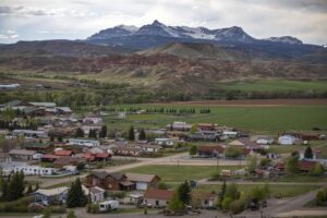
Approximately 30 miles west of here you will come to the mountain community of Dubois. This close-knit town has flavors of tie-hack, cowboy, and pioneer history. Be sure to visit the museum complex which includes the National Bighorn Sheep Center to learn about the largest wintering bighorn sheep herd in the country. If you want to stay over and enjoy the lack of crowds before checking Yellowstone National Park off your bucket list, you’ll find a number of welcoming hotels, cabins, and guest ranches to suit your liking.
From Dubois you will start the gradual climb over Togwotee Pass and the Continental Divide and you’ll immediately be immersed in breathtaking scenery. The jagged rock cliffs to the right of the highway are called the Pinnacles and are a part of the Brecia. Keep your eyes peeled for a sign marking Wind River Lake on your right. One of the many campgrounds located on the Shoshone National Forest, this easily accessible lake affords great fishing, picnic tables and restrooms. Besides, the setting of the lake under Sublette Peak is breathtaking and ideal for a mid-road-trip break.
As you begin the descent toward Yellowstone and Grand Teton National Parks, you will be treated to a spectacular view of the mighty Teton Mountain Range and the Grand Teton. This view is your goodbye from Wind River Country, so we’ll wish you the best and hope y’all come on back.
From the Southeast
If you plan to go through Wind River Country and Yellowstone from Nebraska or Colorado, you will be headed our way on Interstate 80. You may opt to take the Fort Collins cut-off to Laramie via Highway 287 which will intersect with I-80 on the south side of Laramie. In either case, this guide will lead you to Wind River Country.
For those of you who don’t bypass Cheyenne, you will find many interesting places to visit. Cheyenne is the capitol of Wyoming, which gives you the opportunity to visit the Capitol building, state museum, and other historically significant places.
Leaving Cheyenne on I-80, you will begin a gradual climb over the summit of the Laramie Mountain Range. At 8,640 feet, this summit is the highest point on the transcontinental I-80.
The descent down the west side of the of the Laramie Range is much shorter than the climb up from the east. At the base of the summit you will find Laramie and the home of the University of Wyoming Cowboys. The campus is worth exploring. Downtown Laramie is western with interesting shops. The historic Wyoming Territorial Prison here is open to visitors.
From Laramie, head west on I-80 toward Rawlins, a distance of about 100 miles. The mountains on the left are part of the Medicine Bow Mountain Range.
The most direct route to Wind River Country takes you away from I-80 at Rawlins. As you leave the fast, straight pace of the interstate, slow down and enjoy the change of scenery as you go north on Highway 287/789. Approximately 10 miles out of town you will begin to drop into an extremely unusual area. For about 20 miles, you will be in a gigantic depression. The Continental Divide completely surrounds this valley. That means that any moisture—rain, hail, or snow—which finds its way here has no way out. Because there is a little precipitation here, you’ll be driving through a pretty dry Great Basin.
Forty-three miles after leaving Rawlins, you will encounter a highway intersection at what is called Muddy Gap. Turn left and continue north on Highway 789/287. The trip along this route is a treat for history lovers. The Oregon, California, Pony Express, and Mormon Trails run parallel to this road. In some places the highway is right on top of the trail and at one place the trail crosses the highway from right to left. Keep an eye out for historical markers and be sure to stop and check them out. Keep an eye out for the Split Rock landmark and imagine watching it slowly grow nearer while you walked across this landscape next to your wagon. The trails in this area are pristine and a treasure for your first walk in Wind River Country.
Along this section of highway, game animals abound—pronghorn antelope in particular. It is not uncommon to see half a dozen tan bodies with little white rumps on the side of the road or on the near sloping foothills grazing contentedly. The critters often decide to change sides of the highway, so keep an eye out for them on the road.
About 10 miles from where you left Muddy Gap, you will get a view of Castle Rock. It is a solid rock outcropping about the size of a large house near the crest of the low rolling hills on your left. Pioneers named this unusual formation Castle Rock for obvious reasons. Local historians claim Jim Bridger’s signature is carved on the inside of the castle and can still be read. In this same area, the Oregon Trail crosses the highway as pioneers guided hard-working draft animals and wagons around the south end of the slough (where the highway is today).
Down the highway you’ll slow down for Jeffrey City, which was once a booming town with an economy based almost entirely on uranium. When the uranium market fell onto irreversible decline, so did Jeffrey City. Most of the homes you will see are empty. This is a reminder of the old West boom-bust cycle that still exists today.
Approximately 15 miles west of Jeffrey City, a large historic marker on your right tells about Ice Slough, a famous place on the Oregon Trail. On a day when the temperatures reached upward to 100 degrees, pioneers could dig down into the tall grass and find ice. The sign will explain the details. While facing the sign, look up the fence row to your right and you will see a wire gate. Walk up to the gate and look to the north. Here the Oregon Trail is very clear. Look behind you across the highway to see where the Oregon Trail is again visible. This area was a special place for the Oregon- and California-bound pioneers. Not much has changed here in the 150 years since the first pioneers passed this way.
West of the Ice Slough about 10 miles you will come to the intersection of Highway 135. Today, you will turn right on Highway 135 toward Riverton, but you could continue straight to Lander. The first 12 miles will take you across a high grassland and sagebrush area. Look for the wild mustangs that roam this plain. To the left Dish Pan Butte stands alone on the horizon. Just to the left of the butte you will see a small notch in the row of hills which is called Devil’s Gap. In the early 1800s mountain men rode through here on their way to Wind River Country. It was also used later in that century by horse soldiers from Fort Washakie on their way to Sweetwater River Valley to cut hay for livestock at the Fort.
The highway will then suddenly drop into Riverton. The view is magnificent, and the enormity of the land is hard to comprehend. You will be looking west into a gigantic basin between the Owl Creek Mountains to the north and the legendary Wind River Mountains to the south. The ranges come together near Dubois, forming a triangle.
The road descends rather rapidly for several miles, then continues more gently into the Riverton valley, about 18 miles. You will cross two rivers as you approach Riverton: The Little Wind River and the Wind River where Highway 135 intersects with Highway 789 and you take a right.
Riverton is historically an agricultural community and now has more to offer in terms of museums and education and shopping for art and more. I recommend you head straight for the large green overhead sign at the second traffic light, turn left on to Main Street, park, and explore. Riverton has some fantastic eateries with local beef, a number of museums, and more.
 It is only 24 miles from Riverton to Lander on Highway 789. As you drive these miles and enter this picturesque community, soak up the views of the Wind River Mountains ahead. Upon reaching Lander, turn right just after McDonald’s. Stop in at the Visitors Center then head out to explore town and the outdoor recreation opportunities that surround it.
Don’t miss Sinks Canyon State Park. You won’t believe it even when you see the rushing river slam into a rock wall and just disappear. This geographical wonder is in a state park that is free to visitors.
After you’ve explored Lander, take Hwy 287 north to Fort Washakie. Though you’ve only been back on the road for 16 miles, you’ll want to stop to check out Wind River Trading and Maker’s Space 307 for local art and artifacts.
From Fort Washakie, you can take a short side trip to see Sacajawea’s gravesite and memorial. Sacajawea was the young woman who saved the Lewis and Clark expedition by guiding them across much of the Rocky Mountain West. She is buried outside Fort Washakie with her sons.
From the Shoshone Tribal Service Station on the corner of Hwy. 287 and North Fork Road, turn towards the mountains (west) and bear left onto South Fork Road to Cemetery Lane. You will see the cemetery to your right.
Once back on Highway 26, you’ll drive north for about 16 miles. Highway 287 intersects with Highway 26, and you will turn left to get to Dubois, then Yellowstone. Approximately 13 miles from this intersection you will see a large historical marker on your left. There is plenty of room for parking and stretching your legs while you take in the view. This marker gives a version of the legend of Crowheart Butte.
Approximately 30 miles west of here you will come to the mountain community of Dubois. This close-knit town has flavors of tie-hack, cowboy, and pioneer history. Be sure to visit the museum complex which includes the National Bighorn Sheep Center to learn about the largest wintering bighorn sheep herd in the country. If you want to stay over and enjoy the lack of crowds before checking Yellowstone National Park off your bucket list, you’ll find a number of welcoming hotels, cabins, and guest ranches to suit your liking.
From Dubois you will start the gradual climb over Togwotee Pass and the Continental Divide and you’ll immediately be immersed in breathtaking scenery. The jagged rock cliffs to the right of the highway are called the Pinnacles and are a part of the Brecia. Keep your eyes peeled for a sign marking Wind River Lake on your right. One of the many campgrounds located on the Shoshone National Forest, this easily accessible lake affords great fishing, picnic tables and restrooms. Besides, the setting of the lake under Sublette Peak is breathtaking and ideal for a mid-road-trip break.
As you begin the descent toward Yellowstone and Grand Teton National Parks, you will be treated to a spectacular view of the mighty Teton Mountain Range and the Grand Teton. This view is your goodbye from Wind River Country, so we’ll wish you the best and hope y’all come on back.
From Yellowstone Park
Yellowstone Park is—and long has been—a magic place for any who visit it. It maintains its charm and mystery today. The abundant wildlife and the unique physical features, particularly the geysers, are unequaled any place in our nation. Now you get to go beyond Yellowstone and enjoy having a little more elbow room in Wind River Country.
As you exit the park, you will be going south on Highway 89/287/191. A great number of Yellowstone Park visitors have discovered the neighboring destination of Wind River Country and sing the praises of peaceful, stunning Highway 26. So, at Moran Junction, turn left on Highway 26. This highway crosses a small valley and climbs up the west side of the Wind River Mountains. As you climb out of the valley, soak up the spectacular, final view of the Teton Mountain Range behind you. Just after you cross the Continental Divide on Togwotee Pass, at an elevation of 9,568 feet, keep an eye out for beautiful Wind River Lake. It lies to the left of the highway and is just a 100-yard drive from Hwy 26. The view and setting will astound you and welcome you to Wyoming’s Wind River Country.
As you descend into Wind River Country on the east side of the Continental Divide, a panorama of the Wind River and Absaroka Ranges will spread before you. The magnificent pinnacles of the Brecia greet you about halfway down to the valley floor.
Dubois is a charming mountain town with a great deal to offer visitors. Duboiswyoming.org will be able to tell you about all the attractions and events you should see while you’re there. Spend some time learning about the history and wildlife of this region, or join one of the many events hosted by this tight community while you’re in town. If you spend the night, consider one of the fantastic guest ranch experiences.
When you do leave Dubois, take highway 26/287. You will enter the Wind River Indian Reservation about 10 miles from town. Approximately 20 miles into the Reservation, you will notice an enormous butte on your left. This is Crowheart Butte. Look for the information sign on the right so you can stop and gaze at the formation and learn about it.
Thirteen miles east of Crowheart Butte, you can continue straight to Riverton or take a right to Fort Washakie and Lander to further explore Wind River Country.
On Highway 26
If you reach Wyoming from Nebraska, you will do so on Highway 26. Did you know the Mormon Trail and Pony express route share the same trail as the Oregon Trail all the way across Wyoming from Fort Laramie to Fort Bridger? The Bozeman Trail, which led to the gold fields of Montana, also originated here.
Fort Laramie is an absolute “must see” for travelers. It is located a few miles south of the small town of Fort Laramie. Watch for the signs.
From Fort Laramie, head west on Highway 26 to the small community of Guernsey. Stop here to check out Register Cliff and the Oregon Trail ruts a few miles south of town. Both of these sites are national historic landmarks (no admission fee). At Register Cliff, the Oregon- and California-bound travelers would stop briefly to carve their names on the soft sandstone cliffs above the North Platte River. These signatures and dates are still legible today. A few miles west of Register Cliff are the most remarkable ruts of the Oregon Trail you will ever have the opportunity to see. Just follow the signs. There is a parking area and a walk of several hundred yards to the ruts which are four feet deep. You can stand in these deep ruts and follow the trail on foot for a short distance if you so desire. Most visitors do not know about this incredible area so you may very well have this special place all to yourself.
From Guernsey, Highway 26 heads west and intersects with Interstate 25, which you will take to the north. The Oregon Trail crosses this highway from left to right a few miles outside of town. Watch for the historical marker. After traveling north on I-25 for about 12 miles the interstate descends into a small valley. The stream is Horse Shoe Creek. On the right a small ranch house and outbuildings stand where the Horse Shoe Creek stage station was located (mile marker 109.5). The Pony Express and Oregon Trail cross the Interstate at this location from right to left as well.
Continue north on I-25 for 10 miles to exit 151; look for signs to Ayers Park and Natural Bridge, a nice side trip. LaPrele Creek, a small but determined mountain stream, has tunneled its way through a rock wall, leaving a gigantic arch of solid rock. It is a pleasant place to relax, picnic, and wade in the cool water. Few visitors know about this secret little place, and it is a jewel.
Casper has an abundance of fascinating stops waiting to be discovered. Fort Caspar is located on the west side of town. Take exit 188-B, also called Poplar Street. After you exit I-25, turn left at the stop light. You will be on Poplar Street which is also Highway 220. Watch for the brown signs pointing the way to Fort Caspar. Turn right onto Collins Drive. This street will lead you directly into the Fort. Park in the museum parking lot. There is no admission for this excellent museum or for the fort. There are beautiful open areas and a playground near the museum.
When you leave the Fort, turn left on Wyoming Boulevard and follow it approximately one mile to the junction of Highway 20/26. This intersection is clearly marked. Turn left here and you will be back on track to Wind River Country, heading for Shoshoni.
The highway passes through vast expanses of grassland and sagebrush and you get the feeling you are pretty much on your own. Not true. There is a lot going on out here and, if understood, is most enjoyable. First of all, you are passing the south end of the Big Horn Mountains on your right. The Big Horn Mountain Range runs north and south. Where the Big Horns end on the south, the Owl Creek Mountains Begin and stretch the west. You will see the Owl Creek Mountains to the right as you approach Shoshoni. Also, on the left in the distance you begin to see the legendary Wind River Mountain Range.
It is appropriate at this point as you travel between Casper and Shoshoni to mention “Mother Sage.” It is no coincidence that Wyoming supports a majority of the world’s population of pronghorn antelope and sage grouse. The only vast expanses of sagebrush-grassland habitat left on the North American continent are found in Wyoming, Nevada, and Montana. Pronghorn antelope and sage grouse require these extensive uninterrupted native habitats to roam freely between summer and winter ranges. Sagebrush provides the major food source for these species, especially in winter when snow covers most other vegetation.
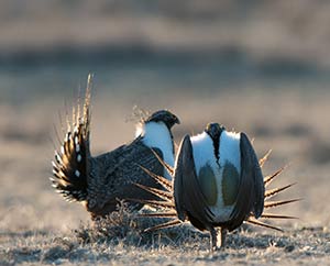
Wyoming sagebrush also supports other unique life forms. The golden eagle, sage thrushes, cottontail rabbits, horned larks, sage lizards, and western jumping mouse are just a few of the over 150 species of wildlife commonly found associated with sage.
While at first glance the sagebrush community takes on the appearance of “wasteland,” it is an integral part of that magic formula which makes Wyoming a wildlife paradise. So, relax and enjoy the vast expanses of the American West. Watch for herds of antelope. You might even see a sleepy cowboy on his horse looking for some lost steers.
Just a few miles west of Waltman’s Corner (mile 53) is where the Bridger Road crosses the highway. This road was laid out in 1864 by Jim Bridger as the shortest route to the Montana gold fields. It was safer and shorter than the Bozeman Trail which led gold seekers to the Montana fields by traveling east of the Big Horn Mountains. The Bozeman Trail had a short and bloody history and was eventually abandoned. The Bridger Cutoff was safer and shorter but was a compromise route to those heading north from the Oregon Trail.
Shoshoni is the first town of Wind River Country you’ll reach. This is a small community located on the edge of sagebrush country and a well-developed agricultural area. It is irrigated from the winter snow in the Wind River Mountains.
Approximately 20 miles west of Shoshoni is the community of Riverton. Riverton is historically an agricultural community and now has more to offer in terms of museums and education and shopping for art and more. I recommend you head straight for the large green overhead sign, turn left on to Main Street, park, and explore. Riverton has some fantastic eateries with local beef, a number of museums, and more.
If you are heading to Yellowstone and/or Jackson from Riverton, you will go west on Highway 26 to the beautiful and rustic mountain town of Dubois. On the way, be sure to watch for the recently introduced Wind River Reservation bison herd just past the tiny town of Morton on the left. About halfway to Dubois, you will pass Crowheart Butte on your right. There is a large wooden historic marker on the left side of the road with ample parking explaining one story of this formation.
The mountain community of Dubois is close-knit and has flavors of tie-hack, cowboy, and pioneer history. Be sure to visit the museum complex which includes the National Bighorn Sheep Center to learn about the largest wintering bighorn sheep herd in the country. If you want to stay over and enjoy the lack of crowds before checking Yellowstone National Park off your bucket list, you’ll find a number of welcoming hotels, cabins, and guest ranches to suit your liking.
From Dubois you will start the gradual climb over Togwotee Pass and the Continental Divide and you’ll immediately be immersed in breathtaking scenery. The jagged rock cliffs to the right of the highway are called the Pinnacles and are a part of the Brecia. Keep your eyes peeled for a sign marking Wind River Lake on your right. One of the many campgrounds located on the Shoshone National Forest, this easily accessible lake affords great fishing, picnic tables and restrooms. Besides, the setting of the lake under Sublette Peak is breathtaking and ideal for a mid-road-trip break.