September 13, 2015

The Loop Road, a 70-mile driving loop from Lander, is open in the summer season and has multitudes of trail heads and access points for recreation along the way. The first seven miles of the Loop Road, starting from Sinks Canyon State Park, is paved. The next 19 miles to Highway 28 is a single-lane, graded gravel road‑acceptable driving conditions for any standard vehicle. This summer, my go-to Saturday morning hike (and still get home with energy for chores and dinner) is variations of exploration on Blue Ridge‑21 miles from downtown Lander, at the highest point of the Loop Road (9500’).
(Tiny Human and Parent)-Friendly Hike
First timers: Keep your eyes and spidey-senses peeled for the Blue Ridge parking lot, approximately three miles after crossing Sawmill Creek. (And by “parking lot” we mean a dirt pull-out on either side of the road with very little and obscured signage.) From a shady parking spot, a ½ mile trail leads to the old Blue Ridge Fire Lookout, a stone-stair structure built in 1938. (Hint: Start at the trailhead sign instead of the fire road.)
From the trailhead you’ll gently climb around 300’ over the course of one-half of a mile on a well-travelled trail through subalpine forest. The route is an easy and accessible walk that will take the tiniest of hikers less than 30 minutes to a steep mountain outcrop. At the base of the outcrop will be signs to the stone stairs leading to the top of the former fire outlook.
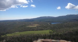
Keep the tiny humans and less-than-clever pets on lanyards up a mildly-exposed, (approximately 80-90) winding stone steps to the stonewall top. The panoramic views at almost 10,000’ include the Continental Divide, Wind River Mountains, Owl Creek Mountains, and the Wind River Basin.
For more information read about The Loop Road and Blue Ridge Lookout
Posted in Notes From the Field